A five-day trek along the Chornohora – the highest ridge in Ukraine. This area belongs to the Carpathian National Park. You will be given an opportunity to watch marvelous views on the whole Carpathian Mountains, reach the highest peak of Ukraine, and feel the unique nature of this region.
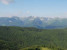
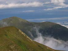
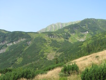
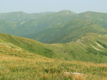
The Chornohora is the highest mountain ridge in Ukraine. The length of the ridge is around 40 km. Almost the half of the ridge has the average elevation of 2000m.
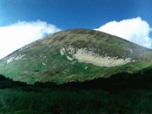
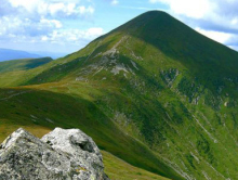
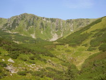
The first impressive mountain is 2020 meters high Petros. Further to the East, the actual highest summit Hoverla (2061m) is located. Both peaks appear to be the beginning of the ridge which goes eastern. The most eastern summit of the Chornohora ridge is Pip Ivan Mt. or Black Mountain (2021 m). Actually this peak is the end of the ridge.
For the several centuries the Chornohora ridge was the boundary between two kingdoms – Poland and Hungary. Even nowadays you can watch the small posts – the signs of the former border. Moreover, you can meet the remains of the World War I.
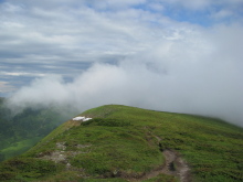
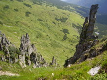
Up to the 1300 m, the slopes of the Chornohora ridge are covered with beech and spruce trees. If you reach more than 1300 m hight, you will be up with the of humble pine growings. Almost all the peaks of the ridge ends with the stone fields. Today the Chornohora ridge is under protection of the Carpathian National Park.
The camping places appeared to be strictly set as we will trek through the territory of the Carpathian National Park.
Itinerary:
Day 1.
Lazeshchyna village – Petros Mt. (2020m) – pasture Skopeska.
The route begins from the village Lazeshchyna. We arrive to Lazeshchyna early in the morning by mini-bus from Lviv. We hike along the river Studenyi to the sheds where shepherds live in summer. You will get the chance to taste the real Carpathian bryndza (a special type of cheese) and to drink the sheeps’ milk. Then you will try yourself at climbing the mountain Petros. After descending from the top we will camp out on the pasture Skopeska to stay there overnight.
Distance to walk: 21 km.
Overfall of the height: 1785m.
Short characteristic of the day route: good dirt road from Lazeschyna village up to the old tourist camp; well-marked path to the crossroad (one path goes on Petros summit, the other one – Hoverla Mountain); the path to the the peak of Petros Mt – rather steep ascent; going back to that crossroad and hiking along the other path to the pasture Skopeska – camping for staying overnight.
Approximate time of the walk: 9 hours
Day 2.
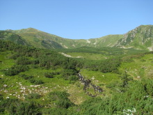
Skopeska pasture – Hoverla Mt. (2061m) – Breskul Mt. (1912 m) – Pozhyzhevska Mt. (1822 m) – Turkul Mt. (1933 m) – the Nesamovyte Lake.
This day you will get a wonderful opportunity to step on the peak of the highest mountain of the Ukrainian Carpathians – Hoverla (Goverla). Then we will slope via several summits to Nesamovyte Lake (an approximate translation would be the Raving Lake) for camping to stay overnight.
Distance to walk: 14 km.
Overfall of the height: 892 m.
Short characteristic of the day route: well-marked path during the whole day; gradual ascent from the camping place to almost the last hundred meters to the highest peak; rather steep ascent to the top of Hoverla Mountain; good path without any abrupt descents or ascents up to the next camping place – banks of the Nesamovyte lake.
Approximate time of the walk: 7 hours
Day 3.
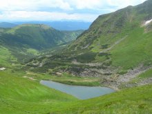
Nesamovyte Lake – Rebra Mt. (2001 m) – Brebeneskul Mt. (2036 m) – Dzembronya (1878 m)
The path runs through the ridge further. We will climb picturesque steep summit Rebra and then Brebeneskul Mt. We will make a little stop for you to see another pearl of the Chornohora ridge – Brebeneskul lake. Then it is convenient to go to the riverbank to camp out. But if there is time, the journey may continue further. We can descent to the river and stay there overnight.
Distance to walk: 14 km.
Overfall of the height: 560 m.
Short characteristic of the day route: well-marked path via several peaks of the Chornohora ridge to the place to stay overnight.
Approximate time of the walk: 7 hours
Day 4.
Dzembronya Mt. (1878 m) – Pip Ivan/Black Mountain (2021 m) – the Maricheyka Lake.
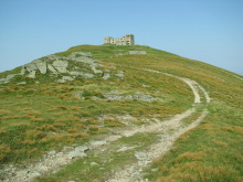
One more peak is waiting for you – Pip Ivan/Chorna Hora (that means Black Mountain). There you can also see the ruins of the old observatory, which was functioning from 1937 till 1939 (right till the World War II bursted out). Our route continues to the lake Maricheyka – the last overnight stay in the mountains.
Distance to walk: 10 km.
Overfall of the height: 1482 m.
Short characteristic of the day route: an ascent back to the ridge from the camping place; well-marked path to the Pip Ivan Mountain with the ruins of old observatory on the top; steep descent to the Maricheyka lake.
Approximate time of the walk: 7 hours
Day 5.
Maricheyka Lake – Zelene village.
This is already the way home. Although, be careful as the descent is rather steep. We will hike along the path which gradually becomes a dirt road to the village. Just the way back on mini-bus to Lviv is left to the end of the trip.
Distance to walk: 9 km.
Overfall of the height: 101 m.
Short characteristic of the day route: steep descent to Shybene village via the path which flows to the good dirt road.
Approximate time of the walk: 4 hours
Tour price is being calculated individually depending on the number of the persons who want join the trek.
The tour cost is being calculated individually and it will include:
- transportation from Lviv to the Carpathians and back by mini-bus;
- food during the trip;
- guide fee;
- insurance.
To reserve the tour please send an e-mail to carpathians@inlviv.com, specifying:
- your name and surname, country;
- how many people you are;
- contact phone number and e-mail;
- the name of the tour;
- starting date,
Please, check what to take with you in a mountain trip.
The tour starts from Lviv, but alternative pick up places could be arranged.
We could offer you to stay a few days after the tour in Lviv. And here you can find information about the hotels, apartments and hostels.


